Malaysian Ringgit


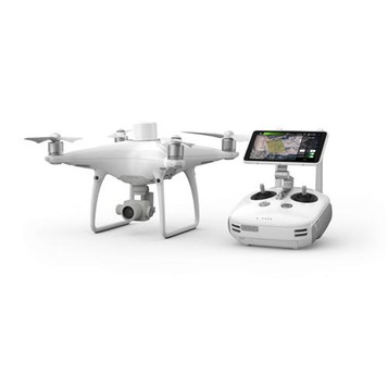

Visionary Intelligence. Elevated Accuracy.

Upgrade your next mapping mission with the Phantom 4 RTK – DJI's most compact and accurate low altitude mapping solution.
Next Generation Mapping

DJI has rethought its drone technology from the ground-up, revolutionizing its systems to achieve a new standard for drone accuracy – offeringPhantom 4 RTK customers centimeter-accurate data while requiring fewer ground control points.
Centimeter Level Positioning System

A new RTK module is integrated directly into the Phantom 4 RTK, providing real-time, centimeter-level positioning data for improved absolute accuracy on image metadata. Sitting just beneath the RTK receiver is a redundant GNSS module, installed to maintain flight stability in signal-poor regions such as dense cities. Combining both modules, the Phantom 4 RTK is able to optimize flight safety while ensuring the most precise data is captured for complex surveying, mapping and inspection workflows.
Fit the Phantom 4 RTK to any workflow, with the ability to connect this positioning system to the D-RTK 2 Mobile Station, NTRIP (Network Transport of RTCM via Internet Protocol) using a 4G dongle or WiFi hotspot, or store the satellite observation data to be used for Post Processed Kinematics (PPK).
Gather Accurate Data with TimeSync

To take full advantage of the Phantom 4 RTK’s positioning modules, the new TimeSync system was created to continually align the flight controller, camera and RTK module. Additionally, TimeSync ensures each photo uses the most accurate metadata and fixes the positioning data to the center of the CMOS – optimizing the results from photogrammetric methods and letting the image achieve centimeter-level positioning data.
Precise Imaging System

Capture the best image data with a 1-inch, 20 megapixel CMOS sensor. Mechanical shutter makes mapping missions or regular data capture seamless as the Phantom 4 RTK can move while taking pictures without the risk of rolling shutter blur. Due to the high resolution, the Phantom 4 RTK can achieve a Ground Sample Distance (GSD) of 2.74 cm at 100 meters flight altitude. To ensure each Phantom 4 RTK offers unparalleled accuracy, every single camera lens goes through a rigorous calibration process where radial and tangential lens distortions are measured. The distortion parameters gathered are saved into each image’s metadata, letting post-processing software adjust uniquely for every user.
Purpose-Built Flight Planning Application

A new GS RTK app allows pilots to intelligently control their Phantom 4 RTK, with two planning modes – Photogrammetry and Waypoint Flight – alongside a more traditional flight mode. The planning modes let pilots select the drone’s flight path while adjusting overlap rate, altitude, speed, camera parameters and more, offering an automated mapping or inspection workflow.
The GS RTK app has been built with its users in mind and therefore has a range of features built for specific mapping or inspection workflows. The app has implemented direct loading of KML area files for in-office flight planning, a new shutter priority mode to keep exposure consistent across all photos and a strong wind alarm to warn pilots of adverse conditions.
Mobile SDK Supported

The Phantom 4 RTK is compatible with the DJI Mobile SDK, opening up its functions to automation and customization through a mobile device.
OcuSync Transmission System
Enjoy stable and reliable HD image and video transmission at distances of up to 7 km, great for mapping larger sites.
*Unobstructed, free of interference, when FCC compliant. Maximum flight range specification is a proxy for radio link strength and resilience. Always fly your drone within visual line of sight unless otherwise permitted.
Seamless Compatibility with D-RTK 2 Mobile Station
Support your Phantom 4 RTK missions with the D-RTK 2 Mobile Station – providing real-time differential data to the drone and forming an accurate surveying solution. The Mobile Station’s rugged design and OcuSync 2.0 transmission system ensures you can gain centimeter-level accurate data with your Phantom 4 RTK in any condition.
Start Mapping Today

With a built-in flight planning app (GS RTK) and aneasymethod to collect RTK data (RTK Network or D-RTK 2 Mobile Station), pilots have a full solution for any surveying, mapping or inspection workflow – right out of the box.
| Phantom 4 RTK | |
|---|---|
| Takeoff Weight | 1391 g |
| Diagonal Distance | 350 mm |
| Max Service Ceiling Above Sea Level | 6000 m |
| Max Ascent Speed | 6 m/s (automatic flight); 5 m/s (manual control) |
| Max Descent Speed | 3 m/s |
| Max Speed | 31 mph (50 kph)(P-mode) 36 mph (58 kph)(A-mode) |
| Max Filght Time | Approx. 30 minutes |
| Operating Temperature Range | 32° to 104° F (0° to 40℃) |
| Operating Frequency | 2.400 GHz to 2.483 GHz (Europe, Japan, Korea) 5.725 GHz to 5.850 GHz (United States, China) |
| Transmission Power (EIRP) | 2.4 GHz CECE (Europe) / MIC (Japan) / KCC (Korea): < 20 dBm 5.8 GHz SRRC(China) / FCC(United States)/(Taiwan,China): < 26 dBm |
| Hover Accuracy Range | RTK enabled and functioning properly: Vertical:±0.1 m;Horizontal:±0.1 m RTK disabled Vertical:±0.1 m (with vision positioning); ±0.5 m (with GNSS positioning); Horizontal:±0.3m (with vision positioning); ±1.5 m (with GNSS positioning). |
| Image Position Offset | The position of the camera center is relative to the phase center of the onboard D-RTK antenna under the aircraft body's axis:(36, 0, and 192 mm) already applied to the image coordinates in Exif data. The positive x, y, and z axes of the aircraft body point to the forward, rightward, and downward of the aircraft, respectively. |
| Mapping functions | |
| Mapping Accuracy ** | Mapping accuracy meets the requirements of the ASPRS Accuracy Standards for Digital Orthophotos Class Ⅲ ** The actual accuracy depends on surrounding lighting and patterns, aircraft altitude, mapping software used, and other factors when shooting. |
| Ground Sample Distance(GSD) | (H/36.5) cm/pixel, H means the aircraft altitude relative to shooting scene (unit: m) |
| Data Acquisition Efficiency | Max operating area of approx. 1 km² for a single flight(at an altitude of 182 m, i.e., GSD is approx. 5 cm/pixel, meeting the requirements of the ASPRS Accuracy Standards for Digital Orthophotos Class Ⅲ |
| Vision System | |
| Velocity Range | ≤31 mph(50 kph) at 6.6 ft(2 m) above ground with adequate lighting |
| Altitude Range | 0-33 ft(0 - 10 m) |
| Operating Range | 0-33 ft(0 - 10 m) |
| Obstacle Sensing Range | 2-98 ft(0.7-30 m) |
| FOV | Forward/Rear: 60° (horizontal), ±27° (vertical) Downward: 70° (front and rear), 50° (left and right) |
| Measuring Frequency | Forward/Rear:10 Hz; Downward: 20 Hz |
| Operating Environment | Surfaces with clear patterns and adequate lighting(> 15 lux) |
| Camera | |
| Sensor | 1" CMOS; Effective pixels: 20M |
| Lens | FOV 84°;8.8 mm / 24 mm(35 mm format equivalent:24 mm); f/2.8 - f/11, auto focus at 1 m - ∞. |
| ISO Range | Video:100-3200(Auto) 100-6400(Manual); Photo:100-3200(Auto) 100-12800(Manual). |
| Mechanical Shutter Speed | 8 - 1/2000 s |
| Electronic Shutter Speed | 8 - 1/8000 s |
| Max Image Size | 4864×3648 (4:3); 5472×3648 (3:2). |
| Video Recording Modes | H.264,4K:3840×2160 30p |
| Photo Format | JPEG |
| Video Format | MOV |
| Supported File Systems | FAT32 ( 32 GB); exFAT (> 32 GB). |
| Supported SD Cards | MicroSD, Max Capacity: 128 GB. Class 10 or UHS-1 rating required Write speed≥15 MB/s |
| Operating Temperature Range | 32° to 104° F (0° to 40℃) |
| Intelligent Flight Battery (Ph4 - 5870mAh - 15.2V) | |
| Capacity | 5870mAh |
| Voltage | 15.2V |
| Battery Type | LiPo 4S |
| Energy | 89.2 Wh |
| Net Weight | 468 g |
| Charging Temperature Range | -10° to 40℃ |
| Max charging Power | 160W |
| Capacity | 4920mAh |
| Voltage | 7.6V |
| Battery Type | LiPo 2S |
| Energy | 37.39Wh |
| Operating Temperature | -20° to 40℃ |
| Intelligent Battery Charing Hub (WCH2) | |
| Input Voltage | 17.3 - 26.2 V |
| Output Voltage and Current | 8.7 V,6 A;5 V,2 A |
| Operating Temperature | 5° to 40℃ |
| GNSS | |
| Single-Frequency, High-Sensitivity GNSS Module | GPS+BeiDou+Galileo*(Asia); GPS+GLONASS+Galileo*(other regions) Frequency Used: GPS: L1/L2; GLONASS: L1/L2; BeiDou: B1/B2; Galileo*: E1/E5a First-Fixed Time: < 50 s Positioning Accuracy: Vertical 1.5 cm + 1 ppm(RMS); Horizontal 1 cm + 1 ppm(RMS) 1 ppm means the error has a 1mm increase for every 1 km of movement from the aircraft. *Available soon |
| Gimbal | |
| Stabilization | 3-axis (tilt, roll, yaw) |
| Pitch | -90° to +30° |
| Max Controllable Angular Speed | 90°/s |
| Angular Vibration Range | ±0.02° |
| Infrared | |
| Obstacle Sensing Range | 0.2 - 7 m |
| FOV | 70°(Horizontal) ±10°(Vertical) |
| Measuring Frequency | 10 Hz |
| Operating Environment | Surface with diffuse reflection material, and reflectivity> 8%(such as wall,trees, humans, etc.) |
| Remote Controller | |
| Operating Frequency | 2.400 GHz-2.483 GHz (Europe,Japan,Korea) 5.725 GHz-5.850 GHz (United States, China) |
| Transmission Power (EIRP) | 2.4 GHz CE / MIC / KCC: < 20 dBm 5.8 GHz SRRC / FCC: < 26 dBm |
| Max Transmission Distance | FCC: 4.3 mi (7 km); SRRC / CE / MIC / KCC:3.1 mi (5 km) (Unobstrcted, free of interference). |
| Power Consumption | 16 W(typical value) |
| Display | 5.5 inch screen, 1920×1080, 1000 cd/m², Android System Memory 4G RAM+16G ROM |
| Operating Temperature Range | 0° to 40℃ |
| Intelligent Flight Batteery Charging Hub (Phantom 4 Charging Hub) | |
| Voltage | 17.5 V |
| Operating Temperature Range | 5° to 40℃ |
| Capacity | 4920mAh |
| Voltage | 7.6V |
| Battery Type | LiPo 2S |
| Energy | 37.39Wh |
| Operating Temperature | -20° to 40℃ |
| AC Power Adapter (PH4C160) | |
| Voltage | 17.4V |
| Rated Power | 160W |
For a drone that’s designed for aerial surveying and 3d mapping, look no further than the new DJI Phantom 4 RTK. Built specifically with surveyors in mind, the Phantom 4 RTK incorporates a new real-time kinematics (RTK) system to maintain positional accuracy and deliver survey-grade data. With this launch, DJI has rethought its drone technology from the ground-up, revolutionizing its systems to achieve a new standard for drone accuracy – offering Phantom 4 RTK customers centimetre-accurate data while requiring fewer ground control points.
It is suitable for the following applications:
- Aerial surveying & 3D mapping
- Inspection
- Photography
Рhаntоm 4 RТК х 1
Rеmоtе Соntrоllеr х 1
Рrореllеr Раіr х 4
Іntеllіgеnt Flіght Ваttеrу х 2
АС Роwеr Аdарtеr х 1
АС Роwеr Саblе x 1
Rеmоtе Соntrоllеr Іntеllіgеnt Ваttеrу (WВ37) х 1
Іntеllіgеnt Ваttеrу Сhаrgіng Нub х 1
Іntеllіgеnt Flіght Ваttеrу Сhаrgіng Нub х 1
Gіmbаl Сlаmр х 1
МісrоЅD Саrd (16GВ) х 1
Місrо UЅВ Саblе х 1
Рhіllірѕ Ѕсrеw х 2
Саrrуіng Саѕе х 1
UЅВ-С ОТG Саblе х 1
UЅВ-С Саblе х 1
Dоnglе х 1

Related Products